
Blog
December 2, 2016
Meet the Team of Trinity Exteriors
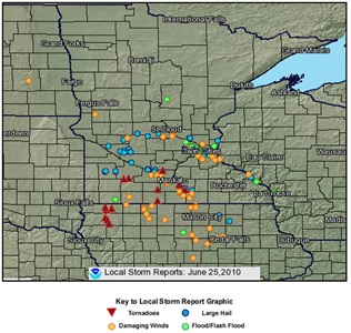
A warm front moving across west and south-central Minnesota yesterday (June 25, 2010) brought with it another bout of severe weather and barrage of damaging hail, high winds and tornados. A total of 9 tornados touched down in the south-central part of the state, around the Mankato area. Large hail and damaging winds were more widespread affecting much of the bottom half of Minnesota including St Cloud, Mankato and the Minneapolis – St Paul areas. Preliminary hail and wind reports from National Weather Service put the magnitude of the storm easily into a category that will cause property damage to most automobiles, homes and businesses. Wind speeds reached upwards of 70 miles per hour and hail reported ranged in size from ¼ inch to over 4 inches, with an average size of 1-½ inches, or about the size of a golf ball. Depending on the age, type and condition of a home or business’s exterior, golf ball size hail can inflict significant damage to the property. Primary areas affected typically include the roof, siding, gutters and windows and can vary widely in the extent of damage done based on a number of factors. If you or someone you know has been affected by this storm, Trinity Exteriors can help. Our trained Service Representatives have successfully helped thousands of business and homeowners through the insurance claims process to a full restoration. Schedule a Free, No Obligation Consultation Today. Below we’ve listed the areas affected by Hail and/or Wind damage in Minnesota as reported to the National Weather Service:
National Weather Service Hail Damage Report for Minnesota – June 25, 2010 (County, Cities, Magnitude):
Anoka: Blaine (0.75) Blue Earth: Mankato (1.00 – 1.25) Brown: New Ulm (1.75) Chippewa: Appleton, Clara City and Milan. (0.88 – 2.75) Dakota: Eagan, Mendota Heights and St Paul. (0.88 – 1.00) Hennepin: Golden Valley, Maple Plain, Minneapolis, New Hope, Orono and Plymouth. (0.75 – 1.75) Kandiyohi: Prinsburg and Raymond. (1.50 – 1.75) Nicollet: Fairfax, New Ulm and St George. (1.50 – 4.25) Ramsey: Roseville and St Paul. (0.75 – 1.75) Renville: Delhi and Fairfax. (1.00 – 1.75) Sherburne: Elk River (0.50 – 2.00) Sibley: Gibbon (1.25) Stearns: Belgrade, Cold Spring, Kimball and Paynesville. (1.00) Swift: Murdock and Sunburg (1.25 – 1.75) Waseca: New Richland and Waldorf (1.75 – 4.25) Washington: Otisville (2.00) Wright: Big Lake and Clearwater. (0.25 – 0.88)
National Weather Service Wind Damage Report for Minnesota – June 25, 2010 (County, City, Magnitude):
Anoka: Blaine Blue Earth: Lake Crystal, Mankato and Minnesota Lake. Brown: New Ulm (58 – 71 mph) Dakota: Apple Valley and Hastings. Faribault: Minnesota Lake and Wells. Freeborn: Alden and Hartland. Goodhue: Redwing Hennepin: Bloomington, Burnsville and Long Lake. Nicollet: Courtland (70 mph) Sherburne: Clearwater Stearns: Kimball Swift: Sunburg Washington: Cottage Grove Wright: Clearwater (65 mph)